


ZuluGaz — hydraulic modeling for gas networks.
ZuluGaz is a set of programs for analyzing and modeling gas networks, designed to perform various industry-specific tasks. It allows users to create mathematical models of networks, and use generated models to perform information tasks, topological analysis, and complete different hydraulic calculations. With ZuluGaz, you can design low, medium and high pressure systems powered by one or several gate stations and pressure regulator stations. It is possible to calculate and analyze gas networks that transport various gas mixtures, whose parameters are specified by the user.ZuluGaz is a set of programs for analyzing and modeling gas networks, designed to perform various industry-specific tasks. It allows users to create mathematical models of networks, and use generated models to perform information tasks, topological analysis, and complete different hydraulic calculations. With ZuluGaz, you can design low, medium and high pressure systems powered by one or several gate stations and pressure regulator stations. It is possible to calculate and analyze gas networks that transport various gas mixtures, whose parameters are specified by the user.
ZULUGAZ FUNCTIONALITIES:
-
Calculating pipeline diameters for gas networks
-
Hydraulic modeling for gas networks
-
Calculating natural gas volume after accidental release
-
Calculating pipeline operating time on residual pressure
-
Calculating reserve network capacity
-
Building pressure drop graphs for gas networks
-
Network switching
-
Longitudinal profiles of gas networks (AutoCAD)
-
Creating process flow diagrams
Analysis and modeling capabilities
ZuluGaz Online Help – Common computational errors
The program allows users to perform calculations and create models for gas supply systems using the following methods:
- SP 42-101-2003 guidelines under normal conditions
- SP 42-101-2003 guidelines for gas temperatures deviating from normal conditions
- STO GAZPROM GAZORASPREDELENIE 12.2.2-1-2013 set of standards. “The process of working with data. Determining flow rate, calculating spare capacity of gas pipelines”.
Users can indicate gas composition; not only natural gas, but also ordinary air.
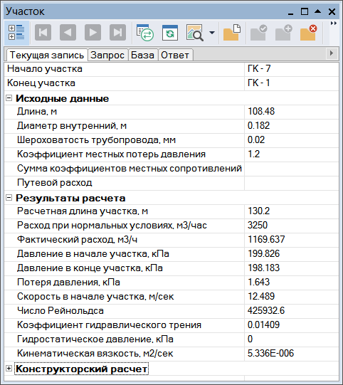
A gas network graph is created in ZuluGIS topology editor. The program generates a computational network model and corresponding tables for each object. Users enter information required to perform calculations into tables; calculated results are also subsequently recorded in tables. You can build a model on a map at scale, georeference it or draw it as a schematic diagram.
See also: Multi-user mode, server for ZuluGIS