


ZuluServer — access geodata remotely through our server
ZuluServer is a server for ZuluGIS that enables multiple users to work with geodata in a local network or on the Internet simultaneously. ZuluServer can serve as a connecting link when developing a corporate geographic information system.
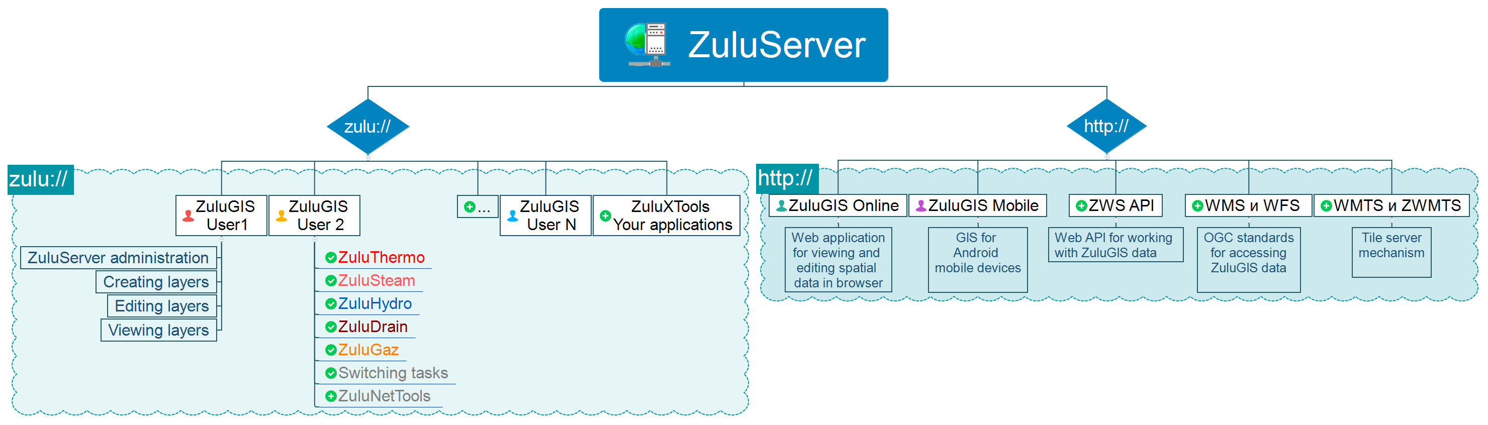
ZuluServer supports two protocols:
- Binary (zulu://) protocol for heavy ZuluGIS clients and independent applications based on ZuluXTools GIS components, which allows users to fully engage with data
- HTTP (http://) protocol for mobile and web applications powered by ZuluServer Web Services
TCP/IP protocol is used to access the server. ZuluServer allows you to deny file access to client apps for data on the server. The client does not have access to information pertaining to physical data storage and cannot make unauthorized changes to data.
In ZuluServer you can set the following security modes: public, secure, enhanced security mode. All ZuluServer users can control access to data. The system of passwords and rights makes it possible to establish different сapabilities and limitations accessing and working with data for different users. Additionally, access rights to server data can be limited by a spatial filter, when the user has access only to those graphic objects that are located in a specific polygon (region, city, district, etc.).
ZuluServer for ZuluGIS
ZuluGIS preserves all the functionalities of the desktop version and can open maps, layers, projects and other data from a remote computer with ZuluServer installed and running.
To connect to ZuluServer, enter the following information:
- Network address for the computer where ZuluServer is running
- Username and password to log onto the server
- Port number used to connect to ZuluServer.
Just like ZuluGIS, ZuluXTools GIS components can work with data located on ZuluServer.
Working with data on ZuluServer
- Data addressing
In the same way that a web browser uses URL (Uniform Resource Location) to access website pages, ZuluGIS uses its own type of URL to direct users to data on ZuluServer. To access data stored on the server, ZuluGIS uses a URL address as seen below:
«zulu://<host>:<port>/<path>/<layer_name>.zl». - Multi-user editing
With ZuluServer, several users can edit the same graphics and tabular data simultaneously. In the meantime, separate rollback logs are kept for every individual user. It is possible to have three or more concurrent sessions on ZuluServer. - Automatic map updates
When one client modifies data, the server notifies all the other clients who are using the same data; therefore data is automatically updated on the map. - Data publishing
ZuluServer is designed to speed up and simplify the process of publishing data created in ZuluGIS desktop app. The physical data files do not change in the process. All that is required is manual customization of the links for ZuluServer or customization with the help of data preparation tools, at which point data will become accessible online. - Data administration
ZuluServer enables users to restrict access to data, establish different access rights and rules. You can provide anonymous data access to general public or limit it for select users by specifying which actions and resources they are allowed to perform and use respectively. You can manage user access in ZuluServer Administrator. - Spatial data filter
It is possible to restrict access to server data for select users or user groups by area defined by a simple or compound polygon.
If you set such a restriction, users will be able to display layers or manage data only within a specified area. - Windows authorization
You can use your Windows credentials when connecting to ZuluServer. Users and groups can be added to ZuluServer from the Active Directory. - Databases (DBMS)
To make access to various semantic databases convenient and efficient, especially when it involves numerous users, ZuluServer provides its own databases. It supports OLE DB and ODBC access technologies and bulk data import in DBMS (BULK INSERT). Login credentials used to access ZuluServer can be transferred to a DBMS server (Microsoft SQL Server, Oracle, PostgreSQL). - Licensing
Licensing is based on the number of concurrent connections to ZuluServer. The number of simultaneous sessions on ZuluServer varies from 3 to 250 and more.
ZULUSERVER WEB SERVICES FOR MOBILE AND IN-BROWSER APPLICATIONS
Users can access data created in ZuluGIS and published on ZuluServer through HTTP protocol.
HTTP protocol is used by various client applications to access ZuluServer, including:
- desktop apps (MapInfo, Google Earth, ArcGIS…),
- mobile apps (ZuluGIS Mobile, Locus…),
- in-browser apps (ZuluGIS Online, Google Api, Open Layers, Yandex Map…).
HOW ZULUSERVER WEB SERVICES WORK
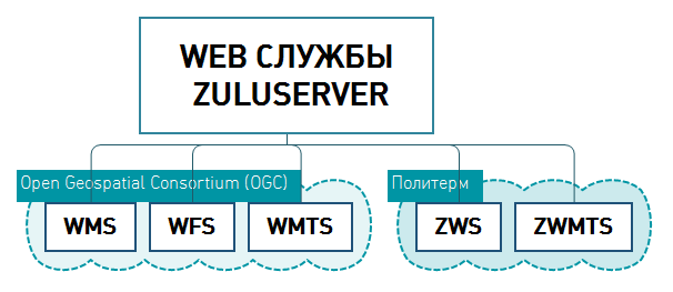
Web services are installed and run in conjunction with ZuluServer. Connection to ZuluServer via web services is currently organized according to the following specifications:- WMS and WFS
ZuluServer allows users to work with server data using WMS 1.1.1, WMS 1.3.0 (Web Map Service) and WFS 1.0.0 (Web Feature Service) protocols developed by the OGC (Open Geospatial Consortium).
WMS/WFS specifications make it possible for client apps that support such specifications to access data created in ZuluGIS. This applies primarily to Google API, Open Layers, Leaflet, Yandex.Maps, MapInfo, ArcGIS, Google Earth and others.
See the examples of how ZuluServer Web Services work here. - WMTS and ZWMTS (Tile server) WMTS (OpenGIS Web Map Tile Service) ZWMTS (Zulu Web Map Tile Service).
You can host a tile system on ZuluServer using the Web Map Tile Service (WMTS) protocol that was developed by the Open Geospatial Consortium, Inc. (OGC), or alternatively, using the simplified ZWMTS (Zulu Web Map Tile Service) protocol designed by our specialists.
ZWMTS and WMTS are open specifications for publishing digital maps online using image caching. A layer with a tile system descriptor that is hosted and published on ZuluServer can refer to data located on the company’s server (maps and digital models developed in ZuluGIS) as well as data from third-party servers. In the latter case, ZuluServer serves as a proxy server that caches data received from the Internet.
See the example of how ZuluServer data sources are enabled for OpenLayers: tileserv.html
You can read more on how ZuluServer works with tile-based data here. - ZWS
ZWS (Zulu Web Service) specification has been developed by our specialists. This protocol is currently used in ZuluGIS Mobile and ZuluGIS Online.
ZWS PROTOCOL ENABLES USERS TO:
- Establish authorized access – configure security policy settings, assign different rules and rights for accessing data
- Receive graphics data – similarly to WMS-based access
- Receive and edit semantic information
- Send SQL queries to layers
- Implement ZuluGIS data visualization parameters – labels, thematic coloring, flow directions in segments of utility networks
- Edit layers. Add new and modify existing elements
- Complete topology tasks and perform network switchovers according to the condition of isolation valves
- Automatically update layers
- Apply a spatial data access filter – data access rights can be limited to an area defined by a simple or compound polygon.
- Create a utility network layer.
- Perform hydraulic calculations and analysis for heat, steam, gas, water supply and wastewater disposal networks using ZuluNetTools components.
PUBLISHING DATA ON ZULUSERVER
How you choose to publish data on ZuluServer depends on the capabilities of your software and the functionalities that will meet your needs.
- Data publishing
When you install ZuluServer Web Services, you also get the ZuluServer 8.0 Web Services configuration tool, which allows you to quickly and easily publish data that you can subsequently work with using the HTTP protocol. The physical data format does not change in the process. . - Data administration
It is possible to restrict access to data published under WMS/WFS and ZWS protocols in the same way that ZuluGIS users are connected to ZuluServer. You can control data access rights using the
You can control data access rights using the ZuluServer Administrator. - Multi-user access
Unlimited users can jointly work with geodata without installing the ZuluGIS desktop application. - Cross-platform reach
Users can access up-to-date information from virtually any device that is connected to the Internet. - Licensing
We offer one license for ZuluServer Web Services regardless of the number of workstations; it depends only on how many queries you run daily. Users of ZuluServer Web Services can access our products, such as ZuluGIS Mobile and ZuluGIS Online, for free.
ZULUGISMOBILE – CLIENT APP FOR ZULUSERVER
ZuluGIS Mobile is a geographic information system for mobile devices running on Android 4.2 or above. It provides the tools needed to work with ZuluGIS data published on ZuluServer – make search queries, display ZuluGIS layer objects on a map, edit graphics and tabular information, send mobile camera images, various documents and location directly to ZuluServer. See the product description page to learn more about ZuluGIS Mobile features.
ZULUGIS ONLINE – WEB APP FOR VIEWING AND EDITING DATA IN BROWSER
This program has been developed in JavaScript using OpenLayers open-source library. ZuluGIS Online makes it possible to display ZuluGIS layer objects on a map, edit graphics and tabular information, and request data from layer databases. You can learn more about ZuluGIS Online features on the product description page.
See also: Hydraulic calculations for water supply systems, Hydraulic modeling for heat networks